Unlike many natural disasters, earthquakes don’t have a “season”. That single fact adds a layer of complexity to an already convoluted hazard. Preparing for a “Summer Earthquake” has some key differences from preparing for a “Winter Earthquake”. Since there’s no way to know when it will come, it’s best to plan for both scenarios.
So, what if the earthquake happens during the summer months vs the winter months? Some of the benefits would include:
Camping weather for those who are displaced, including pets
Fewer viruses circulating on day 1
Easier to keep things sanitary (less mud, mold, etc.)
Dry fuel for building fires
Dry paths for easier, safer evacuation routes
Children not in school
Local food to harvest like fresh blackberries
Warm temperatures for sanitation activities
Sunlight stretching several hours longer than in winter
Fewer people struggling with seasonal affective disorder (SAD)
Sounds pretty good right? When asked, most PNW residents say they’d prefer a summer quake to a winter quake, but what would the challenges look like?

Before diving into the challenges, it’s important to note that some of the most difficult challenges will not be limited to the day the earthquake strikes. Infrastructure will take time to restore in the aftermath of the earthquake and tsunami. Estimates from the Oregon Resilience Plan, shown here, illustrate how even if the earthquake happens on a cool spring day in May, residents in the impacted areas may have to deal with months of hot weather before infrastructure is restored.
You can read through this page in its entirety or click these buttons to jump to a specific “Summer Challenge”. This list is not all-inclusive! If you think of other challenges that would be good to include on this page for others to consider, please reach out on the contact page.
Wildfires
Oh, misty eye of the mountain below
Keep careful watch of my brothers’ souls
And should the sky be filled with fire and smoke
Keep watching over Durin’s sons
“I See Fire”
by Ed Sheeran
During the Labor Day fires of 2020, a strong easterly wind battered forests along the drought-stricken Cascade Mountain range. According to the Oregon Forest Resource Institute, “The Labor Day 2020 windstorm resulted in five simultaneous “megafires”– fires greater than 100,000 acres in size – in Oregon, as well as 12 other fires ranging from 112 to 50,951 acres. All these fires either started or blew up on Sept. 7 and 8, 2020, and in a matter of days more than 1 million acres burned.”
Four of those megafires approached the Willamette Valley, looking, on this map like the approaching footprints of a massive beast. Entire cities were lost. Nine people were killed. It was one of the worst disasters Oregonians have faced.
Oregon Department of Forestry GIS database

Throughout that event, residents relied on radios, phones, the internet, and television for information on the latest evacuation orders. However, during the aftermath of a massive CSZ earthquake and tsunami, normal communication avenues will be nearly non-existent. Communicating evacuation orders will be incredibly difficult. Additionally, lack of fuel and damages to water infrastructure, roads, and bridges throughout the region will make fighting fires much harder. With wildfires likely raging in other states across the west coast, national resources will be strained. Jump to Addressing the Challenges for information on how to prepare.
CEI Hub
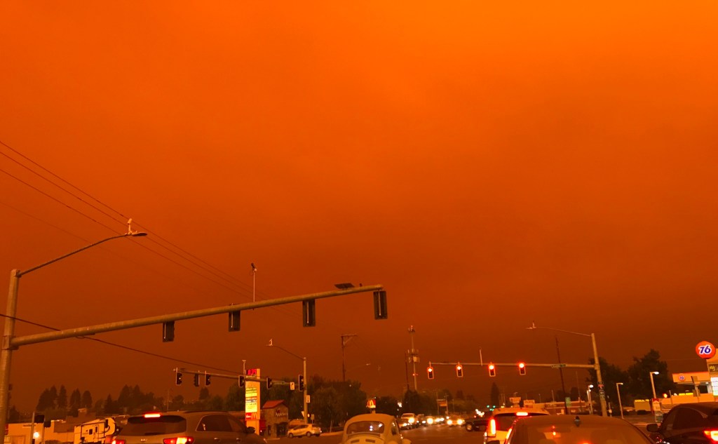
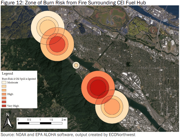
The Critical Energy Infrastructure Hub (CEI Hub) in Portland offers a unique challenge with regard to fires and smoke. Holding 90% of Oregon’s liquid fuel supply, the fuel tanks are not expected to survive the shaking of a magnitude 8 or 9 CSZ earthquake. According to the report, Impacts of Fuel Releases from the CEI Hub Due to a Cascadia Subduction Zone Earthquake by EcoNorthwest, 57% of released materials will seep into the earth while the other 43% will flow into the rivers. Many of these fuels are flammables and some are explosive.
Those living in the areas surrounding the CEI Hub need to be aware of the risks ahead of time, as some will need to evacuate the area incredibly fast. In hot, windy, summer conditions, the fire could spread well beyond what’s shown. The report state:
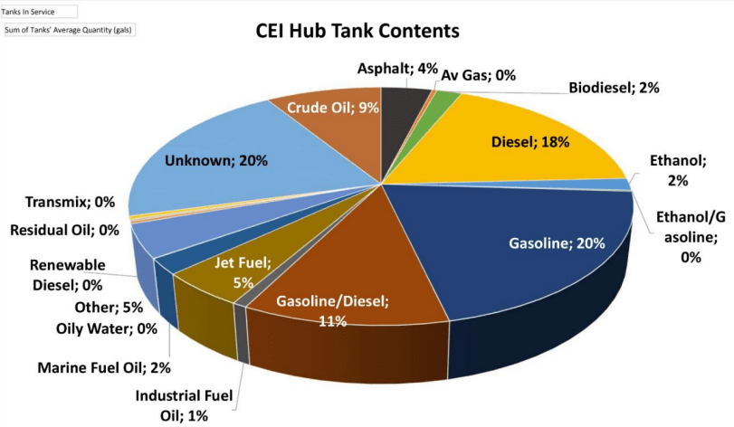
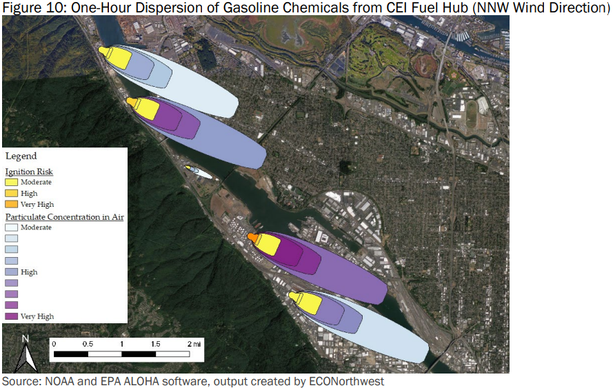
Figures 10 and 11 show a map of the projected area of toxic vapor risk under two prevailing wind conditions for the area surrounding the CEI Hub109. Dark, shaded areas are likely to exceed or greatly exceed the OSHA 8-hour time-weighted average limits for gasoline particulate exposure. The yellow zones immediately surrounding each tank area represent the zones at risk of fire ignition. Depending on the severity, location, and spread of the spill, the concentration of hazardous gasoline vapor may extend beyond these regions. Figure 12 shows the levels of risk of mild to severe burns. The highest zone of risk from a burning gas fire represents a high probability of death within 60 seconds of exposure.
Jump to Addressing the Challenges for information on how to prepare.
Broken Gas Mains
The violent shaking of the earthquake will break gas mains. Despite automatic shutoff valves, it is believed there will still be resulting fires. Know how to shut off your gas after the shaking.
“The greatest damage of the 1906 earthquake occurred when many of San Francisco’s water and gas mains were ruptured. Leaking gas was the catalyst for fires that quickly spread throughout the city and the lack of water made fire fighting a challenge. Approximately one hour after the earthquake, the San Francisco Fire Department sent a messenger to the Presidio to request an artillery division to assist with the containment of fires. Several hours later, artillery troops from Fort Miley arrived in San Francisco and unsuccessfully attempted to control the fires by dynamiting strategic buildings. By noon, the financial district was engulfed in flames and when evening fell the city center had also been incinerated.” – National Park Service
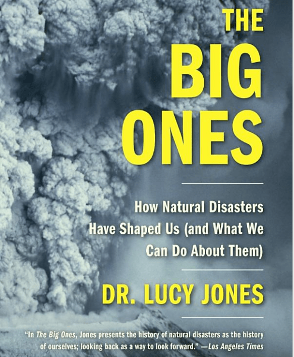
Dr. Lucy Jones is a world-renowned seismologist. In her book, The Big Ones:
Natural Hazards That Have Shaped Us (And What We Can do About Them) she describes leading a team of more than three hundred experts for a project called ShakeOut, in which they anticipated what a San Andreas earthquake might be like. Regarding the program’s scenario, Dr. Jones writes,
“I got to specify the weather. I made it a cool, calm day. Unfortunately, I don’t get to do this for the real thing. If the earthquake happens during the infamous Santa Ana winds, which have spread Southern California wildfires and caused billions of dollars in losses, the fires that get started may be unstoppable.”
While the Pacific Northwest doesn’t have Santa Ana winds, the Labor Day fires of 2020 certainly show how the same may be true in the aftermath of a Cascadia Subduction Zone earthquake. And like Dr. Jones, we don’t get to choose when it happens. Keep in mind too, that research has shown the CSZ and the San Andreas to be at least partially synced. It is possible for the CSZ to trigger the San Andreas which would certainly impact response efforts up and down the West Coast of the US.
Camping and Cooking
Portland Fire & Rescue officials responded to 443 homeless tent or campfires in 2021. It’s a staggeringly high number considering it represents only one metropolitan area and relate to current unhoused residents. A full rupture of the CSZ would affect parts of California, Oregon, Washing, and British Columbia, Canada. The Oregon Seismic Safety Policy Advisory Commission (OSSPAC) estimates that Oregon alone will increase its houseless population by around 27,600 displaced households after the earthquake. Another 18,385 displaced households are expected in Washington.
Without traditional electric and gas stoves to cook food, open fires will become a primary means of cooking. They will also be a means to stay warm. If not maintained properly, those camping fires pose serious risks.
… and fires can move fast.

A Forbes article titled, “The Terrifying Physics Of How Wildfires Spread So Fast” states, “Fires can travel quickly: up to 6 miles-per-hour in forests and up to 14 miles-per-hour in grasslands. If you have an upward slope to your terrain, the flames can travel even faster; an extra 10 degrees of slope will double the speed of your fire.” This is further explained in the video below. Jump to Addressing the Challenges for information on how to prepare.
Tourism
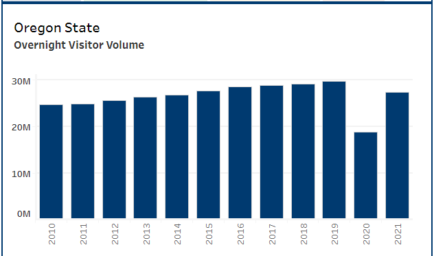
While the Pacific Northwest has a reputation for getting too much rain, that rain helps make the region absolutely breathtaking. Summers are beautiful and draw millions of tourists. Even during the first year of the Covid pandemic, Oregon received an estimated 20.2 million visitors, which according to Travel Oregon was 32% lower than in 2019.
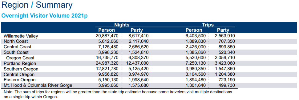
Oregon’s beaches are filled with tourists during the summer months. Ensuring those tourists understand what to do and where to go in the event of a tsunami is key. After the earthquake and tsunami, those coastal tourists will add to the unhoused population in need of supplies and evacuation. The same can be said for tourists throughout the impacted area from Cape Mendocino, CA all the way up to Northern Vancouver Island, BC.
Drought
The western US often falls prey to droughts. Even at the end of 2022, when the rain is falling more often than not, much of the Pacific Northwest remains blanketed in chronic drought conditions.
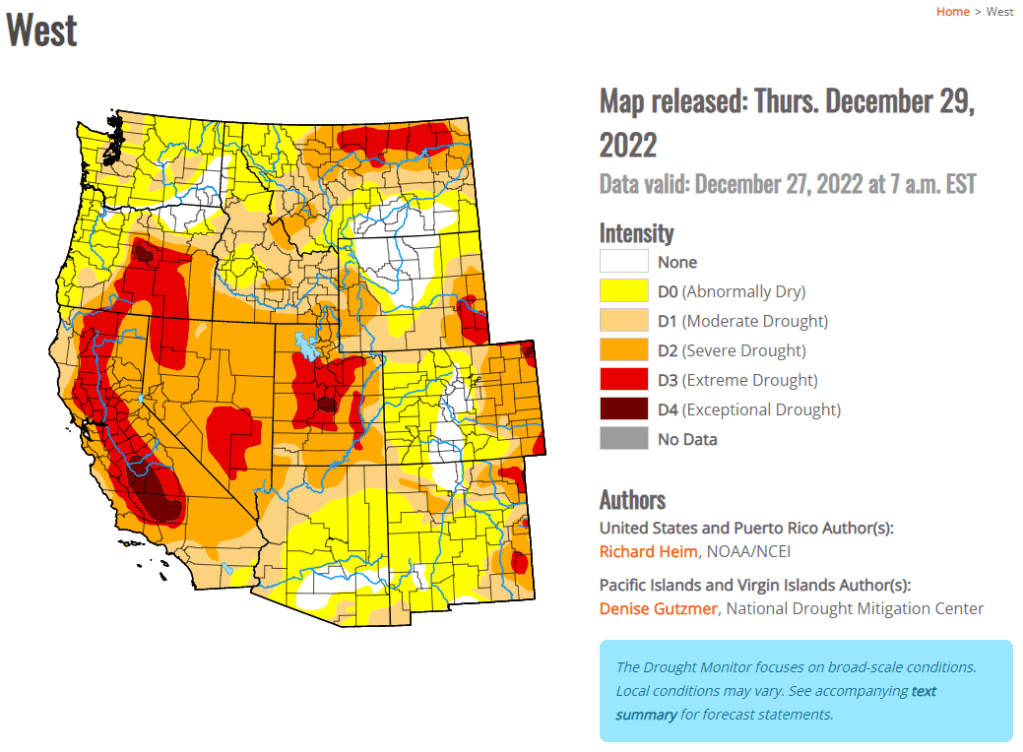
Not only do drought conditions increase the risk of fires, they also impact available water. For those imagining a drenched Pacific Northwest and planning to obtain their drinking water through rainwater collection, understand that water distribution centers won’t be up and running for at least 2 weeks.
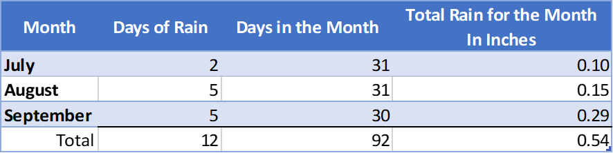
Here is data from Weather. Gov showing the number of days Salem, Oregon received rain during a three-month stretch in 2022. Note that 80 of the 92 days during this timeframe saw not even a trace amount of rain. You can only live without fluids for 3 days. Please, please, please don’t bank on rainwater collection. Storing 2 weeks of water may be cheaper and easier than you think. Visit Surviving Cascadia’s water page for more info.
Extreme Heat
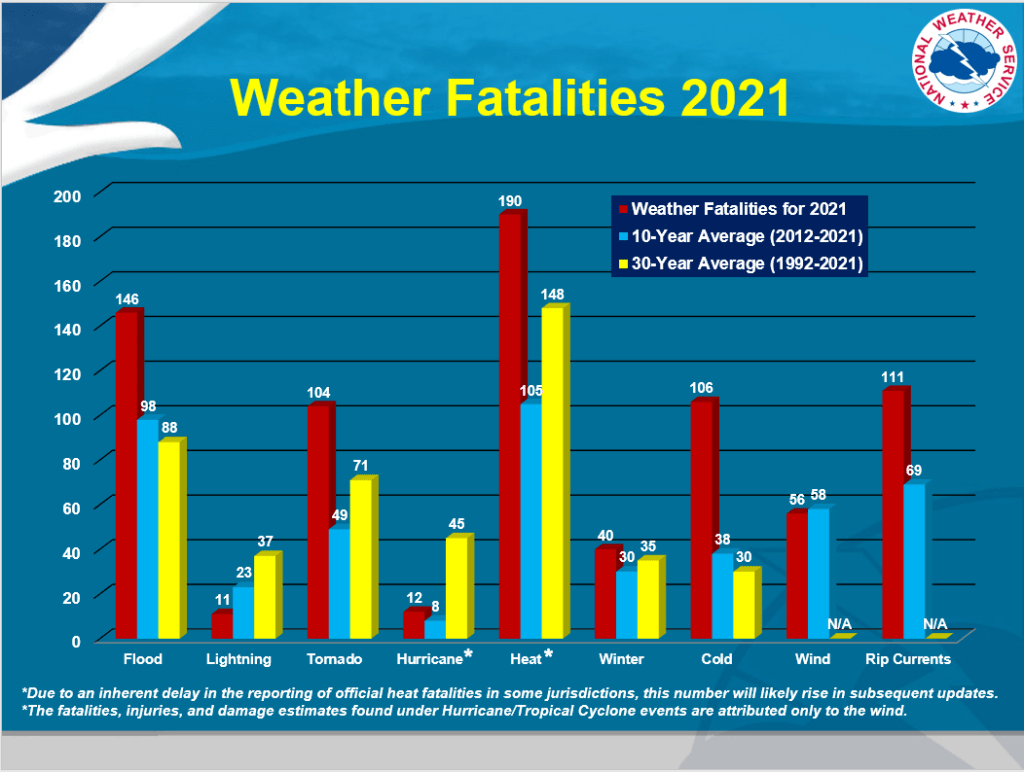
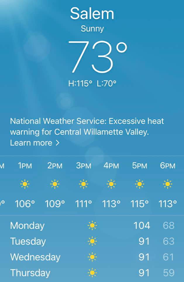
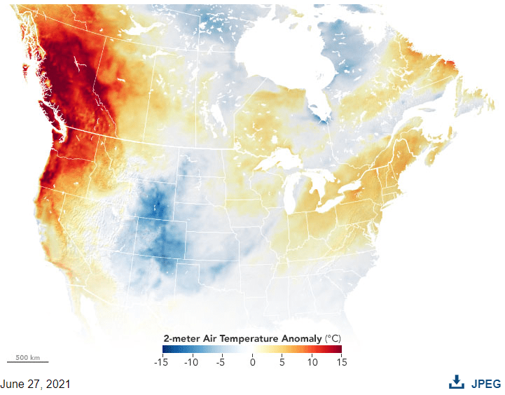
As you can see in the bar graph above, heat can be deadly. In June of 2021, a heat wave hit the Pacific Northwest. I took this screen snip on the left with my phone the morning that Salem was predicted to hit 115°F at 5pm. We ended up topping out at a whopping 117°F. Before that day, Salem’s all-time heat record had been 108°F. The NASA Earth Observatory notes that Seattle hit 120°F. Portland, Oregon, reached an all-time high of 116°F, and Lytton, British Columbia, hit a whopping 121°F. Like Salem, these three temps shattered previous records.
“Extraordinary heat events occur around the planet during most summers, but the current heatwave in the Pacific Northwest is truly exceptional. In June 2021, all-time temperature records fell in multiple cities in the U.S. and Canada during a heatwave that the National Weather Service called “historic and dangerous.”” – NASA Earth Observatory
A study out of the University of California’s Institute of the Environment and Sustainability and the National Center for Atmospheric Research, Boulder, CO, USA found that the heatwave was truly exceptional.
“By drawing on climate model simulations from regions that are analogous to the Pacific Northwest, we find that similar events can be simulated by climate models, but that they are very rare: when they occur, they are often the largest event across nearly 10,000 years of data.”
While temps like that don’t happen often, temperatures do climb into the high 90s and low triple-digit range each year, posing health risks. In the aftermath of the earthquake, the need to engage in an increase of physical labor is likely. Air conditioners aren’t going to be running for most people. Drinking extra water (meaning you need to plan to have extra water) will be critical. Once water distribution centers are open, it’s likely you’ll need to walk to the location and fill jugs (that you provide), then transport them home. In the heat, that’s an extra challenge.
Cyanotoxins
According to the Oregon Health Authority, “Cyanobacteria are not algae at all. They are primitive bacteria found naturally in fresh and salt water all over the world. They are a beneficial bacteria that helped to create and sustain our oxygen atmosphere. In Warm weather, nutrients and low water flow can help these bacteria multiply quickly into what we call a bloom. Sometimes these blooms can produce cyanotoxins that can be harmful to people and pets.”
“Exposure to cyanobacteria and cyanotoxins can be serious and result in a range of symptoms including skin rash, diarrhea, cramps, vomiting, numbness, dizziness and fainting. Children, people with weakened immune systems and pets are most vulnerable to illness.”
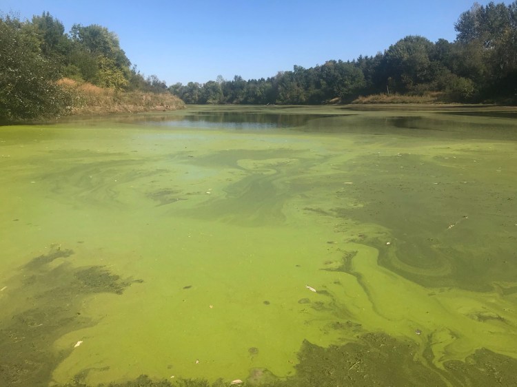
These blooms occur in the warmest months and will affect the availability of water resources in the aftermath of a summer earthquake. (Never drink water from a river without properly filtering it, even if these isn’t a bloom!). OHA goes on to say, “Stay out of water in or around a bloom and keep children and pets away. Never drink or cook with affected water, and do not allow your pet to drink water from the area. Although toxins are not absorbed through the skin, if you or your pet come in contact with a bloom, wash your skin or your pet thoroughly with another source of water and soap if available.”
Vector-borne diseases
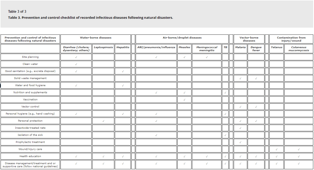
According to research out of the United Nations University International Institute for Global Health,
“Natural disasters including floods, tsunamis, earthquakes, tropical cyclones (e.g., hurricanes and typhoons), and tornadoes have been secondarily described with the following infectious diseases including diarrheal diseases, acute respiratory infections, malaria, leptospirosis, measles, dengue fever, viral hepatitis, typhoid fever, meningitis, as well as tetanus and cutaneous mucormycosis. (ARI=Acute Respiratory Infection)
Some of these diseases are transported through vectors like rats, mice, and mosquitos. While rats and mice can breed year-round, they prefer to do so in a warm environment. Mosquitos prefer the warm weather. During the summer months, encounters with them may be more frequent, particularly for those displaced by the shaking and tsunami. Keeping food, garbage that won’t be picked up by normal service trucks, and human waste contained will help keep them at bay. Consider having mosquito and rodent repellants, as well.

False Sense of Security Around Evacuating
Summer is going to increase that temptation with its beautiful weather, long days that provide for more travel time, and dry paths. For more information about the prospect of evacuating, visit Surviving Cascadia’s After the Shaking page.
Addressing the Challenges
So, what can you do to help protect yourself when the time comes? A lot of what you’ll be able to do will depend on how much you put in place BEFORE it comes. This brings to mind terms like preparedness and resilience. The Electrical Infrastructure Security (EIS) Council uses the term “continuity plan”. The premise of all three is the same. You need to take the time to get ready before the hazard occurs. Here are some suggestions:
Masks
Remember, electricity won’t work after the earthquake, so air filtration systems won’t work either. Windows will likely be broken as a result of the shaking, so indoor air quality might differ much from what’s outside. For fires, make sure you have NIOSH-approved N95 masks for the smoke for adults. The CDC has a list of reputable suppliers. The non-profit, Project N95 is a great resource for finding top-quality kid’s masks.
Communications
Let’s face it, if fires are moving in your direction, you’ll need a way to be notified so you can get out of harm’s way. With cell phones, landlines, and the internet down, you’ll need an alternative way to communicate. It comes down to situational awareness. You can’t utilize information to make decisions… if you can’t access the information.

If you want to be in a position where you can be part of a two-way information flow, consider a Ham Radio. This particular model is available from Amazon for about $70.00. The National Association of Amateur Radio has some really great information about licensing. They offer the exam questions for you to review (you don’t have to pay for a class if you feel confident learning the information on your own.) They also have ways to sign up for the exam and many more resources worth viewing.
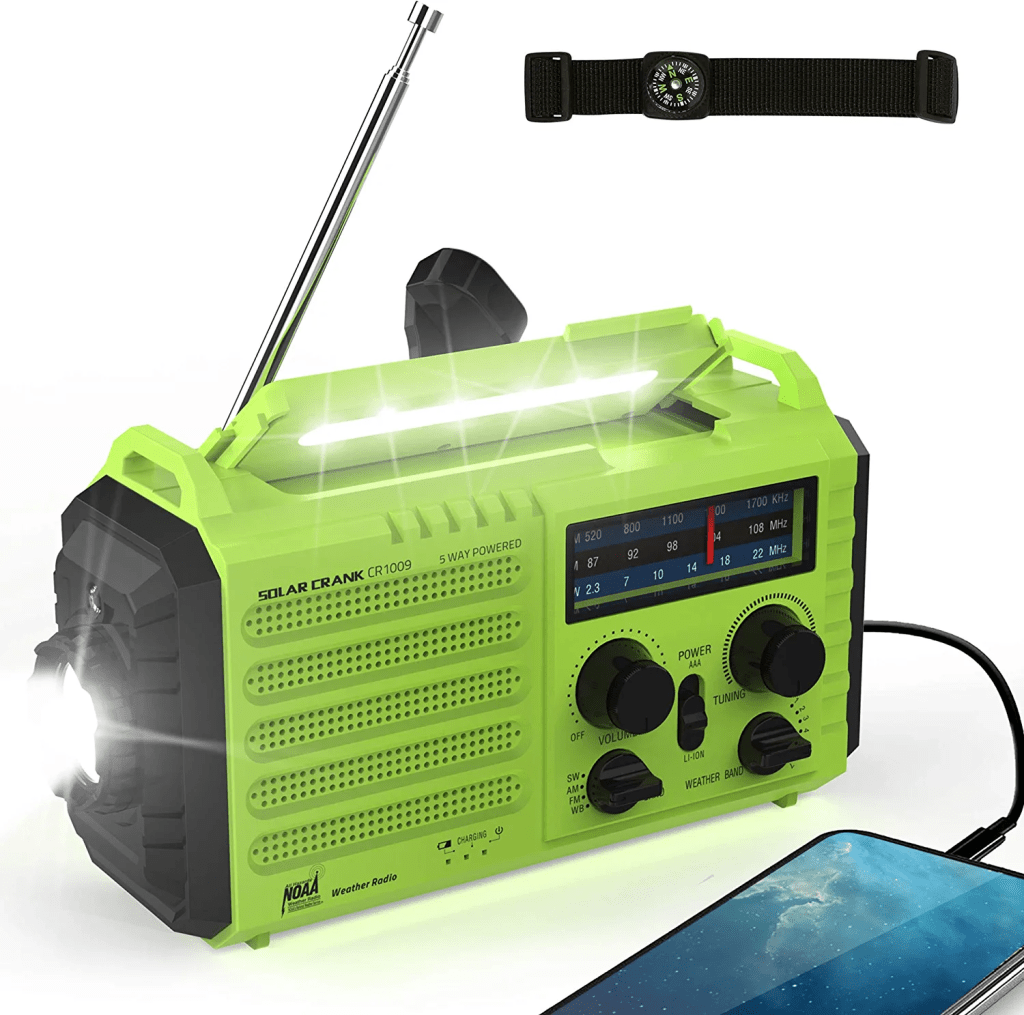
Learning a new skill is a big step! If you’re okay with one-way communication and just want a way to access information, consider a hand-crank NOAA radio. Amazon sells them for between $20 & $70. (While Amazon is a great tool for viewing options and for convenience, consider buying locally to support your community if you can.)

A free option that takes little time—designate an Out of Area Emergency Contact. Make sure your family has the phone number for the contact written down. After an emergency, texts may be able to get through, even if calls can’t. Texts that go outside the impacted area have the best chance for success. For more information about creating an Out-of-Area Emergency Contact, Check out the State of Washington’s information and printable cards.
A word of caution though; cell phones need to be charged. Unless you have a solar power or hand-crank phone charger (HINT: The radio from above also charges your phone!!), or a generator (and the gas to power it), that phone won’t be an option for long. Will it still have power 5 days after the earthquake? 12 days? 42 days? According to the Oregon Resilience Plan, the Willamette Valley is expected to go as much as 3 months without electricity (visit Surviving Cascadia’s Electricity page for more info).

Heat-Related Resources
The National Weather Service and Red Cross have some great resources about heat safety, including graphics on how to treat heat-related illnesses. Since the internet will be down, consider printing tips like those as they will be helpful when you can’t Google the info.
One Final Thought
Make sure to have go-bags ready in case you can’t shelter in place for any reason. Also, I can’t think of anything scarier than having a NOAA radio that tells you that you need to evacuate due to an approaching fire and not knowing how to get to the place you are supposed to evacuate. As the internet will not be working, have a detailed map of your area and several maps of areas around you!
