“Civilization exists by geological consent, subject to change without notice.”
― Will Durant

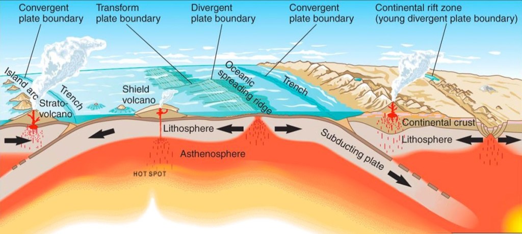
To understand Cascadia, it’s important to understand about plate tectonics. The earth’s crust is much like the shell of a cracked egg. Each section of crust is called a tectonic plate. According to Berkeley University, Plates interact in three ways:
- Plates move away from each other at what are called divergent boundaries (also known as spreading centers);
- *Plates move towards each other at convergent boundaries, where continents collide creating mountain ranges or one plate sinks beneath another plate at a subduction zones and can form volcanic arcs;
- Plates slide past each other at transform boundaries creating strike-slip faults.
*Cascadia
Image Credit: NGS Magnified
There are three overarching earthquake fault types, described in this video.
In general:
- Normal faults lie on divergent boundaries (extension)
- *Reverse (thrust) faults—think Cascadia megathrust earthquake—lie on convergent boundaries (compression)
- Strike-slip faults lie on transform boundaries (shear)
According to the United States Geological Survey (USGS), the Pacific Northwest experiences three types of earthquakes:
- Shallow crustal earthquakes on shallow crustal faults (can generate up to ~Mw7.5).
- Located in the upper 18 miles of the earth’s crust
- Shaking lasting between 20 and 60 seconds.
- Intraslab earthquakes on deep intraplate faults (can generate up to ~Mw7.5), aka deep earthquakes.
- Can impact a larger area than shallow earthquakes but tend to be less intense
- Shaking generally lasts less than one minute.
- Plate interface earthquakes on subduction zone megathrusts (can generate up to ~Mw9.3).
- According to Washington DNR, “What makes these faults ‘mega’ is that the amount of energy released is hundreds to thousands of times more than almost any other type of fault.”
- Shaking can last between 3 and 7 minutes
Image Credit: USGS

“We learn geology the morning after the earthquake on ghastly diagrams of cloven mountains up-heaved plains, and the dry bed of the sea.”
—Ralph Waldo Emerson
Just offshore of the Pacific Northwest lies the Cascadia megathrust fault (CMF), a fault capable of producing some of the world’s most powerful earthquakes and tsunamis.
The Cascadia Megathrust Fault is a reverse fault, aka thrust fault which lies on a convergent plate boundary known as the Cascadia subduction zone (CSZ).
Image: University of Vermont
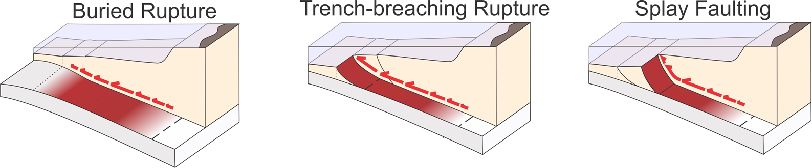
A November 2024 DOGAMI publication, Improved Cascadia Earthquake Source Models for Tsunami Hazard Assessment, looked at three primary ways the Cascadia Fault could rupture; Buried, Trench-breaching and Splay. Splay faults are important because the subduction earthquake can triggered the splay fault to also rupture.
“There’s a huge amount of displacement on these [splay] faults that can create those really quick, local, large tsunamis, so you have that local tsunami coming in really quickly and right behind that, you’re going to have the tsunami that was created by the subduction zone itself. All of a sudden you’re having these massive and destructive tsunamis kind of coming in rapidly one after another.” –Jessica DePaolis, postdoctoral fellow in Virginia Tech’s Department of Geosciences, 2024.
“Because splay faults branch at a steep dip angle from the plate-boundary décollement in an accretionary wedge, their co-seismic displacement can potentially result in larger tsunamis with distinct characteristics compared to megathrust-only fault ruptures, posing an enhanced hazard to coastal communities… The abundance of surface-deforming splay faults in the active outer wedge domain suggests Cascadia megathrust events may commonly host distributed shallow rupture on multiple splay faults located within 30 km of the deformation front.” – USGS, 2024

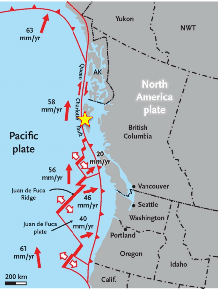
At the Cascadia subduction zone, three distinct tectonic plates (Woods Hole Oceanographic Institution’s Investigations for Geohazards in the Pacific Northwest):
- The Explorer Plate (there are some questions as to whether this plate is still actively subducting. Data does not support Cascadia earthquakes rupturing that far north. See Part 3: Queen Charlotte-Fairweather Fault for more information.)
- Juan de Fuca Plate
- Gorda plate
are diving (subducting) beneath the North American plate at a rate of 1.2 to 1.6 inches (30 to 42 millimeters) per year, Image Credit (Chock, 2022). The image below from Yale University shows the movement at 40 mm/yr.
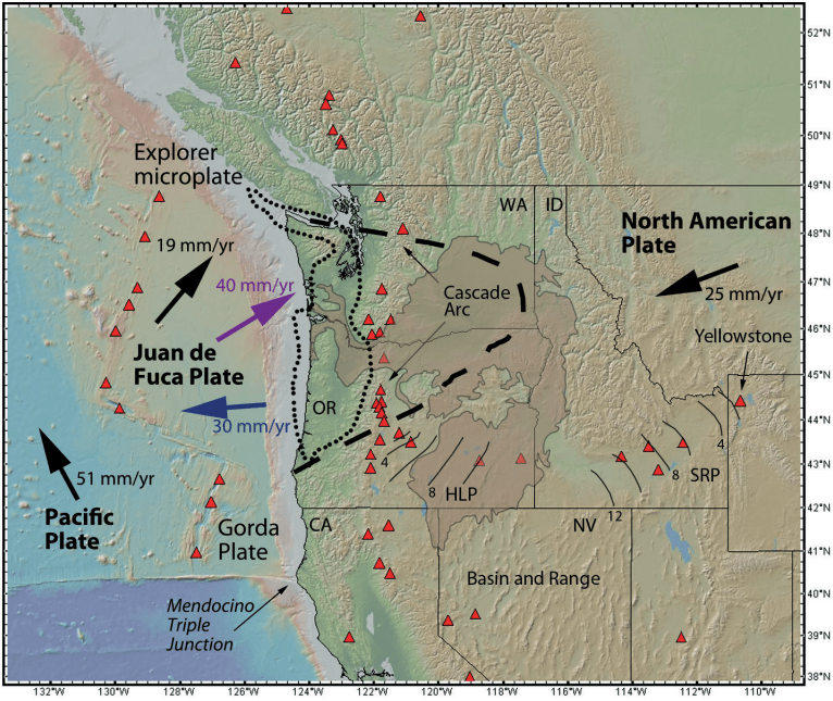
between the Juan de Fuca and North American plates, and the thick blue arrow shows the rollback of the trench.
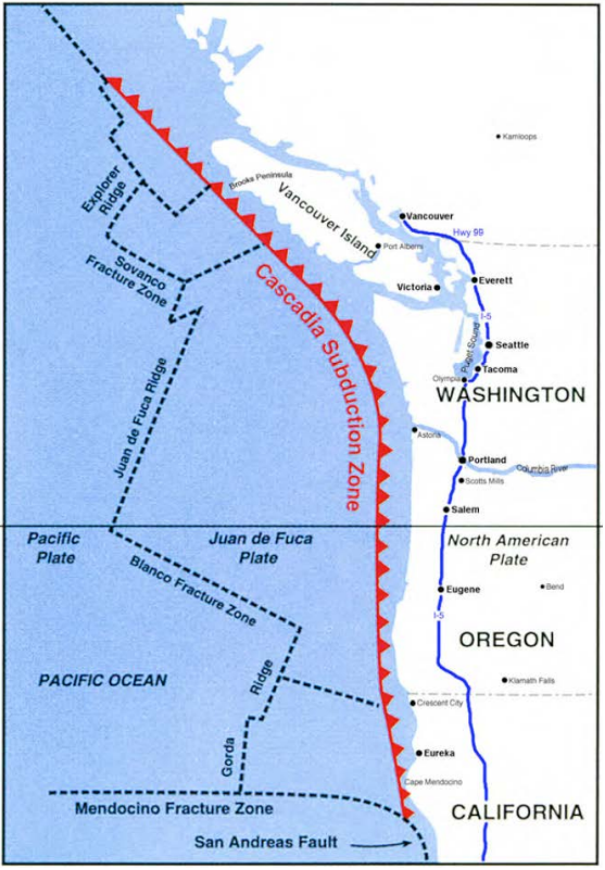
The southern end of Cascadia ends at the Mendocino triple junction, characterized by the intersection of the:
- Pacific Plate
- North American Plate
- Gorda plate
At the zone, three faults meet:
- Mendocino Fracture Zone
- Cascadia Subduction Zone
- San Andreas Fault
Image Credit: California Cascadia Subduction Zone Earthquake and Tsunami Response Plan
The northernmost point of Cascadia ends at the Explorer Triple Junction (Rohr 1995), characterized by the intersection of the:
- North American Plate
- Explorer Plate
- Pacific Plate
At the zone, three faults meet:
- Juan de Fuca Ridge
- Cascadia subduction zone
- Queen Charlotte-Fairweather Fault
Image Credit: (Fossen, 151)
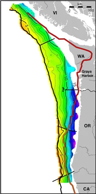
The Cascadia Megathrust Fault is broken up into main 4 segments.
- Northern California ↔ Cape Blanco, Oregon
- Cape Blanco ↔ Alsea Bay
- North of Alsea Bay ↔ the mouth of the Columbia River
- Southern Washington ↔ southern Vancouver Island
For more information about how these segments play into how big the next “big one” might be, visit Part 1: Cascadia’s Impact Area.
Check out these trailers for the OPB documentary, Unprepared: An Oregon Field Guide Special and Rumblings: Preparing for Cascadia. They provide overviews of what the region faces. The full-length feature of Unprepared is available to watch for free on here.
Check out this 26-second video of a surface crack appearing during an earthquake (look behind the gate)! A discussion about the video is available on Facebook’s Pacific Northwest Earthquake Discussion Group, which is moderated by field experts.
The National Earthquake Information Center records about 20,000 annual global earthquakes7. That’s roughly 1,440,000 earthquakes since 1950.
To help visualize just how much the planet is moving, NOAA & NWS created this animation of every recorded earthquake between January 2000 and December 2015. The size of the circles that pop up for the 2004 Indonesia quake and the 2011 Japan quake is striking.
Check out this additional interactive app (which this web template doesn’t have the capability to embed just yet so you have to click the link). It shows earthquakes between July 2017 and July 2018 on an interactive globe.
You can click and drag to rotate to any spot on the globe and scrolling with your mouse will allow you to zoom in or out. Clicking on a specific earthquake will provide a pop up providing details for the event.
However, of those 1.4 million that have occurred since 1950, only 5 have reached the ≈Mw 9.0 range. All occurred along subduction zones similar to the Cascadia Subduction Zone, This chart provides some facts about those five in comparison to the last major Cascadia earthquake on January 26th, 1700.
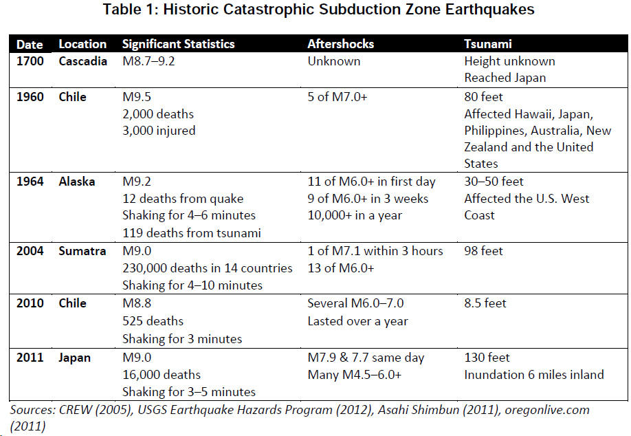
Check out this quote regarding the 1960 subduction zone earthquake in Chile, shown in the table above, which measured a whopping magnitude 9.58.
What became known as the Great Chilean Earthquake revealed something new about the planet — that the world itself can vibrate like a guitar string. The seismic waves went through every part of the globe, even its core. And because they were so strong, scientific instruments from around the world picked up the signal. When it was over, seismologists realized the earthquake had given them a window into Earth’s structure. Nature had given the planet something like an ultrasound scan.
Of note: Earthquakes release two kinds of waves: “P-waves travel through solids, liquids, and gases. S-waves only move through solids. Surface waves travel along the ground, outward from an earthquake’s epicenter. Surface waves are the slowest of all seismic waves, traveling at 2.5 km (1.5 miles) per second.” The P-waves are more gentle and go about twice the speed of S-waves. It is these waves that trigger early warning systems to alert that an earthquake is coming (If the distance from the epicenter to another location is far enough, the warning can occur before the more damaging S-waves reach an area). Check out the USGS Earthquake Early Warning system for more info.
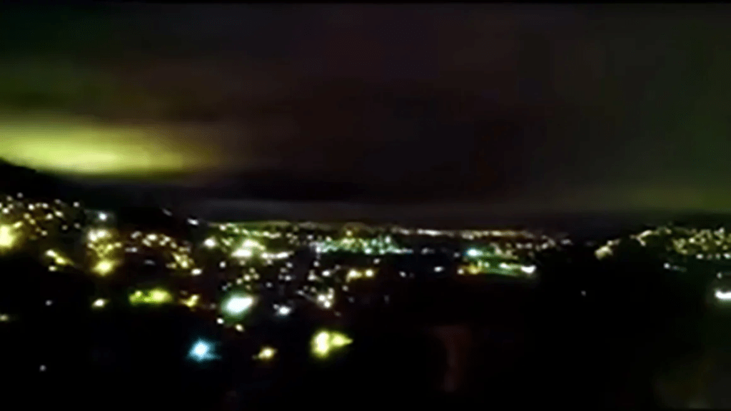
Earthquake Lights
According to the USGS, “Phenomena such as sheet lightning, balls of light, streamers, and steady glows, reported in association with earthquakes are called earthquake lights (EQL).”12 The cause of EQLs is not well understood by the scientific community, but there are theories.
“Prior to earthquakes, huge volumes of rock — hundreds of thousands of cubic kilometers of rocks in the Earth’s crust — are being stressed and the stresses are causing shifting of the grain, the mineral grains relative (to) each other…It’s like switching on a battery, generating electrical charges that can flow out of the stressed rocks into and through unstressed rocks. The charges travel fast, at up to around 200 metres per second.” – Friedemann Freund, adjunct professor at San Jose University and a former researcher at NASA Ames Research Center.13
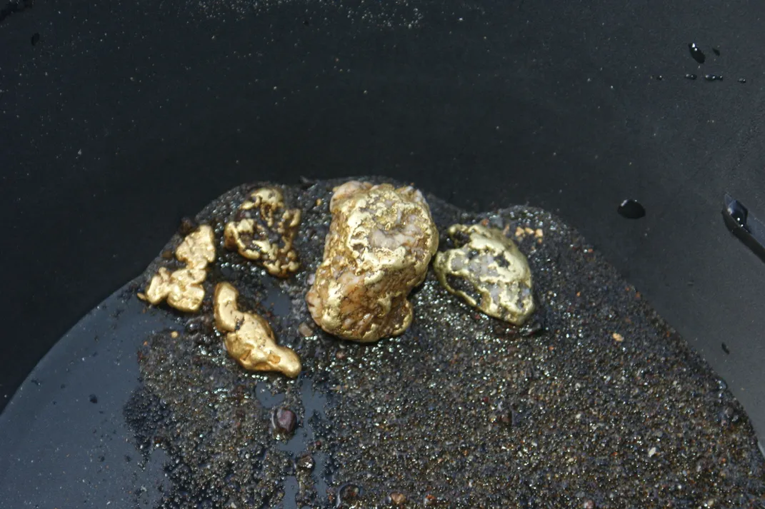
Earthquake Gold
A 2023 research publication in Nature Geoscience found that gold nuggets may form in quartz during earthquakes. New Scientist posted an article on the research that states, “Quartz crystals produce electricity when they are deformed by mechanical stress, which may explain how enormous chunks of gold can form in inert rock.”
“You can, you should, and if you’re brave enough to start, you will.”
― Stephen King
When (not if) the earthquake and tsunami happen, water, wastewater, food distribution, electricity, and natural gas will all be heavily impacted. Bridges, air transportation, rails, roadways, and seaports will be compromised. Some fire and police departments, hospitals, and schools will be heavily damaged. So will some homes. Most communication systems will be down. (See Surviving Cascadia’s Expected Impacts page for more details).
Daily life will look all but unrecognizable. Getting ready for that eventuality takes planning! You are smart & resourceful. But being resourceful requires having access to resources. Those resources are plentiful now. Toilet paper anyone? (Hint: The resources won’t be plentiful after a major event).
Learning about the earthquake and tsunami that will hit the Pacific Northwest is flat-out scary. Striking without warning, earthquakes are some of the greatest ghost stories ever told. They are nowhere, then suddenly everywhere around us at once, unseen but for the destruction they cause.
Be Ready.
Be ready so that you don’t become a victim in need of saving. There are people (and pets!) who can’t prepare in advance the way you can. Be ready so you can help others when the time comes.
Just be ready.
Because you see, for most people, the true risk won’t be the earthquake itself. The true risk is not being ready for the earthquake’s aftermath.
As you travel along this journey seeking knowledge, as you take steps to prepare yourself and your loved ones, the fear will dissipate. It will transform into determination. Let this website serve as a guide on this journey. You’re here. That, in and of itself, is courageous. You’re taking the first step. Not all those around you will be so brave. Keep learning. Start planning. Prepare. Your loved ones will need you to be ready when the time comes.
There is a ghost on our horizon.
