FEMA’s Region 10 Cascadia Subduction Zone (CSZ) Earthquake and Tsunami Plan 2022 lists the following regarding a full-margin rupture:
- 27 counties, including areas impacted along the Pacific Coast, Puget Sound, and Columbia River
- At least 17 tribal nations impacted
- 453 miles of impacted Pacific Ocean coastline (296 miles in Oregon, 157 miles in Washington)
- 1,810 miles of impacted Puget Sound coastline, including the San Juan Islands
- 10- to 30-minute warning for coastal areas
- 90- to 120- minute warning for Puget Sound areas
- All seaports on the Pacific coast at risk of sustaining complete damage; seaports along Puget Sound and the Columbia River (west of the I-205 bridge) at risk for major damage
- Thirty-six percent of Oregon and 42% of Washington coastal county populations live in the inundation zone.
A 2001 document, Designing for tsunamis: seven principles for planning and designing for tsunami hazards, prepared by the National Tsunami Hazard Mitigation Program, states:
“900,000 people in Alaska, California, Hawaii, Oregon, and Washington
live in areas in danger of being inundated by a 50-foot tsunami”.
Details for the figure can be found in Jackson State University’s paper, Assessing the Vulnerability of the US Pacific North West Region to Tsunami Hazards, from which the following table comes.

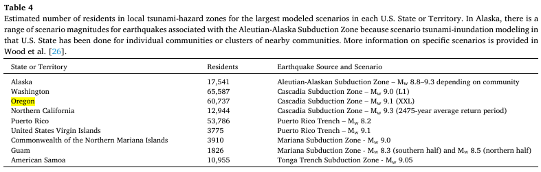
A more recent 2025 analysis in the International Journal of Disaster Risk Reduction, National population exposure and evacuation potential in the United States to earthquake-generated tsunami threats, lists the following figures for residents at risk. This does not include visitors which can double and even triple population levels during peak tourist seasons.
Oregon’s 2015 Cascadia Rising Exercise Scenario Document estimated the following. Strangely, the total number of residents, non-resident workers, and tourists for the data in Washington align with the 2001 data. However, Oregon’s 2015 numbers are much larger than those from the 2001 estimate.

How many people will actually be located within the inundation zone is hard to predict. As with most things, the answer is “it depends”. Unfortunately, looking at just the first and last rows above, it’s clear that a large portion of those in the inundation zone when the earthquake happens, however many there may be, may not survive if they don’t move quickly enough.
Resiliency 2025: Improving Our Readiness for the Cascadia Earthquake and Tsunami states, “Oregon’s at-risk population is approximately 40,000 on the outer coast, excluding tourists and visitors that seasonally swell the population manyfold”.
Oregon Department of Geology and Mineral Industries (DOGAMI) has released updated figures—and the estimates are much higher now. The upper limit just for Oregon exceeds 80,000 fatalities. To learn more, check out Surviving Cascadia’s storyboard. For more information about the estimated expected impacts, visit Surviving Cascadia’s Region, Oregon, Washington, and California pages (a page for BC is in the works—this is a volunteer effort, so I’ll get to it as soon as I’m able.)
The best way to survive a tsunami if you are in an inundation zone when the earthquake happens is to begin evacuating as soon as the shaking stops. Don’t wait around. Let’s look at why that is. DOGAMI’s December 2024 publication, Vertical Structures and Other Tsunami Evacuation Improvement Options in Seaside and Cannon Beach, Clatsop County, Oregon estimates that it takes an average of 7 minutes to collect people/things and begin to evacuate. The publication then adds three minutes to account for the estimated shaking duration. Together, the estimate a total of 10 minutes that pass between when the shaking starts and when the evacuation starts. Why is this so critical to understand?
The publication estimates that Oregon needs between 10 & 15 VES structures while Washington needs more than 80. Currently there are only three along the entire coastline and funding has been approved for three more. It’s good progress, but many more are needed.
Check out this simulation by the Washington Department of Natural Resources. The waves reach towns like Ocean Shores within 20 minutes following the start of the shaking and continue to pulse in and out of Grays harbor for several hours. Despite the outflows, Ocean Shores remains under water the entire time, though the depth fluctuates.
It’s worth noting, too, that the population is expected to continue to grow in the Pacific Northwest. The following quote relates to expected population changes between 2011 and 2061.
Across the region, 2061 population exposure in tsunami-hazard zones was projected to increase by 3880 households and 6940 residents.
Projecting community changes in hazard exposure to support long-term risk reduction: A case study of tsunami hazards in the U.S. Pacific Northwest – USGS
