According to the Pacific Northwest Seismic Network (PNSN)1 and the United States Geological Survey (USGS)2, the length of the offshore Cascadia Megathrust Fault is ≈1,000 km. More specifically, OSU Professor Emeritus Chris Goldfinger states that the Cascadia Megathrust Fault is 1,027 km (638.148 miles) at the deformation front (the area off shore where the two faults meet). If Cascadia is measured along the coast range (helpful for emergency managers who want to evaluate impacts along the length of coast that would be impacted) its length is ≈1,080 km (671.081 miles).
Running from Cape Mendocino, California all the way to about the middle of Vancouver Island, BC, the area on land expected to be directly impacted by the shaking of a magnitude 9.0 earthquake covers 140,000 square miles — an area just slightly larger than all of Germany — and is home to roughly 23.8 million people.
Even light shaking may be felt inland as far as Boise, Idaho and as far south as Sacramento, California. In 2018, a State of Oregon audit found that of the nearly 4 million people living in Oregon, 90% will be directly impacted by this disaster5.
So how big might the next Cascadia megathrust earthquake be? New research by Indiana University and the University of Kansas, released on April 23, 2024, states,
“We find that a release of slip accumulated in the current Cascadia and Nankai locked zones would result in earthquakes of magnitude Mw 8.78-8.89 and Mw 8.73, respectively.” (Sherrill et al. 2024)

Does this mean that the next Cascadia earthquake will be this strong? Not necessarily. It means that enough strain has accumulated so that IF the entire portion of the locked zone ruptured the magnitude could, as of today, reach a magnitude that high.
Two historical Cascadia megathrust earthquakes, events T3 (Mw 8.87) and T5 (Mw 8.80), are estimated to have fallen within the magnitude range of Mw 8.78-8.89. These images illustrate the estimated area of rupture, shown in red. (The orange color represents a rupture along the Northern San Andreas Fault shortly after the CSZ rupture.)
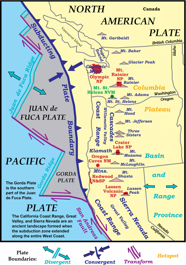
Image Credit: Oregon Legislature

The State of Oregon Cascadia Subduction Zone Catastrophic Earthquake and Tsunami Operations Plan3 explains that the fault could rupture at close to 2.5 km/second…
Which means IF the full length of the fault ruptures & IF it ruptures at that speed the entire time, the earthquake has the potential to cause almost 7 minutes of shaking.
1,027 km / 2.5 km/second = 410.80 second
410.80 seconds / 60 seconds/minute
≈ 6.85 minutes… of shaking
According to the United States Geological Survey (USGS), however, the 1964 Great Alaska Earthquake and Tsunami that measured a magnitude 9.2 created shaking that lasted 4.5 minutes.
According to the 2016 region wide Cascadia Rising exercise, Cascadia has the potential to be the largest natural disaster the United States could face.6 The largest CSZ earthquakes over the past 10,000 years were events T11 and T16. The latter created a turbidite about three times the mass of the most recent ~M9.0 earthquake on January 26th, 1700.9 What does that look like for estimating the PNW’s upper range of what magnitude is possible?
Oregon’s Department of Geology and Mineral Industries (DOGAMI) included a magnitude 9.4 as the largest hypothetical CSZ earthquake in its research, Variable Rupture Scenarios for Tsunami Simulations Inferred From a 10,000-Year History of Cascadia Megathrust Earthquakes.10
The USGS paper, Simulated tsunami inundation for a range of Cascadia megathrust earthquake scenarios at Bandon, Oregon, USA, states the following:
“The extra-large (XL) size class reflects a single event (T11) in the Holocene record of Cascadia turbidites (Table 1). T11 is the second largest turbidite by mass and has the longest post-event time interval (∼1150 yr). We rounded the interval for the extra-large scenario to 1200 yr for the purpose of modeling a hypothetical maximum earthquake with peak slip (>40 m) similar to the Mw 9.5 1960 southern Chile earthquake (Barrientos and Ward, 1990; Moreno et al., 2009).”11
Uder the California Department of Conservation, the California Geological Survey – Seismic Hazards Program published the CGS Special Report 241 – Maritime Tsunami Response Playbooks: Background Information and Guidance for Response and Hazard Mitigation Use in 2016. Table B.10 in the report lists the maximum magnitude for Cascadia at a 9.3, while Table E-2 shows some magnitude 9.43 & 9.44 data points also being considered in scenarios.

Not every megathrust earthquake ruptures along the entire fault. During the past 10,000 years, roughly half of Cascadia megathrust earthquakes have been partial ruptures. In this image:
- The area shaded in red represents how much of the fault ruptured during particular events.
- Events where the entire fault ruptured are shown in segment A. They create ∼Mw9 earthquakes.
- When a partial rupture occurs (shown in the other segments), the result is an earthquake in the ∼Mw8 or high Mw7 range.
- Earthquake “names” are listed in white lettering on the left of each segment (example, T1).
- There is some debate about whether the 3 events shown in Segment B should be considered full-margin ruptures (like those in Segment A) or partial ruptures.
- The 4 events in Segment E are small enough that their status as “official Cascadia megathrust events” have recently been called into question. It is possible that the events occurred on the Northern San Andreas fault, rather than the CSZ, for example. Lead scientists on this project do not include them in the record anymore.


So just how big will the next CSZ quake be? Scientists don’t know for sure. Magnitude is basically a function of rupture length and width. The longer the ‘unzipping,’ the larger the magnitude. According to the USGS:
- Mw4 ~ 1 km (0.621 miles) long
- Mw7 ~ 40-60 km (25-37 miles) long
- Mw9.1 Sumatra fault ~ 100’s of km (62+ miles)
The last bullet point is a bit misleading, as per the quote below, the full rupture length during that earthquake was over 1,200 km (745.645 miles). According to InTeGrate (supported by the National Science Foundation (NSF)) the shaking lasted between eight to ten minutes—eek!
“The 26 December 2004 Sumatra-Andaman earthquake initiated slowly, with small slip and a slow rupture speed for the first 40 to 60 seconds. Then the rupture expanded at a speed of about 2.5 kilometers per second toward the north northwest, extending 1200 to 1300 kilometers along the Andaman trough.” (Ammon et al., 2005)
Here are the estimated magnitudes for the past 42 events (42 events in 10,272 years = an average of 1 major earthquake every 245 years). They are arranged from smallest (Mw7.54) on the top left to the largest (Mw9.13) at the bottom right. Click on the image to enlarge! Event names match those listed in the segment image above (and shown larger on the next page).

A 2019 article by the American Association for the Advancement of Science, “Drones reveal earthquake hazards hidden in the abyss” states,
“At the Cascadia subduction zone off the Pacific Northwest, for example, GPS stations on land suggest that enough strain has accumulated to drive a magnitude-9 earthquake when the fault finally ruptures.
But the land-based measurements also hint that strain along the fault’s midsection, off the coast of Oregon, is being relieved by a type of harmless slip called creep. That suggests the fault could rupture in pieces, in a series of independent, smaller quakes. But without offshore measurements, scientists only see half the picture, says Harold Tobin, a geophysicist at the University of Washington in Seattle.”
In a 2022 presentation at the Cascadia Copes Hub Geohazards Virtual Workshop with State & Federal Agency Partners, Pacific Northwest Seismic Network Director Harold Tobin stated, “The area that’s shown, that’s kind of colored in there is what we call the Landward vergence zone, but that’s really a stand in or a proxy for the portion of the Cascadia subduction zone that’s seen as having the strongest locking which means the strongest potential for the largest slip in future events over large areas and that really encompasses the offshore Washington to northern Oregon region as you can see.”
A Washington Post article discussing the recent research states, “But the scientists found that the geometry of the fault off the coast of Washington, where the fault is flat and smooth, closer to the surface and extends farther onshore, may be particularly at risk.”


Popular Science also has an article on the research. In it, OSU Professor Emeritus Chris Goldfinger is quoted as saying, “We’re in this situation where we’ve discovered a ticking time bomb [beneath] fragile cities… People tend to think collapsing buildings are limited to Turkey or Haiti–places that have [no or poorly enforced] building codes. But the Pacific Northwest is in the same boat as Turkey and Haiti because we didn’t have building codes that were up to snuff until 1994…We’ve got a very fragile infrastructure and a coming big earthquake. What are we supposed to tell people about that?”
Many amazing efforts to mitigate the risk have been accomplished or are currently in the works. They will help save lives and lessen the impacts to the built and natural environments, and so the region must keep advancing as those efforts until the last possible moment. Simultaneously, we must make time to prepare for Cascadia. For information regarding the potential impacts Cascadia may have, check out Surviving Cascadia’s page for the Region, as well as those for Oregon, Washington, and California.
At the southernmost tip, Cascadia meets the Northern San Andras Fault (NSAF, image A). During the past three thousand years, for every Cascadia megathrust earthquake greater than a magnitude 7.5, the NSAF experienced a major earthquake after—sometimes within hours of the Cascadia earthquake. The longest timelapse is thought to be no more than 30 years. In other words, of Cascadia’s most recent 14 major earthquakes (over an Mw7.5) every. single. one triggered a rupture on the San Andreas fault. To view the research, visit Part 2: San Andreas Fault.


At the northernmost tip, Cascadia meets the Queen Charlotte Fault. Visit Part 3: Queen Charlotte Fault for more information.
