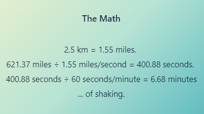
Just offshore of the Pacific Northwest lies a fault capable of producing some of the most powerful earthquakes and tsunamis on Earth. According to the Pacific Northwest Seismic Network (PNSN)1 and the United States Geological Survey (USGS)2, the length of the offshore Cascadia Megathrust Fault is 1,000 km (621.37 miles).
When the time comes, the State of Oregon Cascadia Subduction Zone Catastrophic Earthquake and Tsunami Operations Plan3 states the fault could rupture at close to 2.5 km/second. At that speed, a full margin rupture along this fault would create over 6 minutes of shaking. The fault is massive.
Running from Cape Mendocino, California all the way to about the middle of Vancouver Island, BC, the area on land expected to be impacted by the shaking of a magnitude 9.0 earthquake is home to roughly 15 million people4. In 2018, a State of Oregon audit found that of the nearly 4 million people living in Oregon, 90% will be directly impacted by this disaster5.
Fracturing of Earth’s Crust
The image below shows three earthquake types and three plate boundaries where those earthquake types frequently occur (NOAA, 2023). The Cascadia Megathrust Fault is a reverse fault, shown on the right below, and is on a convergent plate boundary known as the Cascadia Subduction Zone (CSZ).
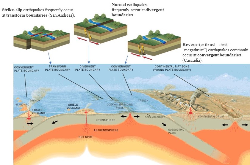

At the Cascadia Subduction Zone, three distinct tectonic plates—the Explorer, Juan de Fuca, and Gorda plates—are diving (subducting) beneath the North American plate, Image Credit (Chock, 2022). Here is a quick one-minute video showing the process.
The CSZ has, according to the Cascadia Rising exercise, the potential to be the largest natural disaster the United States could face.6
It’s worth noting that the National Earthquake Information Center records about 20,000 annual global earthquakes7.
That’s roughly 1,440,000 earthquakes since 1950. Of those 1.4 million, only 5 have reached magnitude 9 or larger. All occurred along subduction zones similar to the Cascadia Subduction Zone.
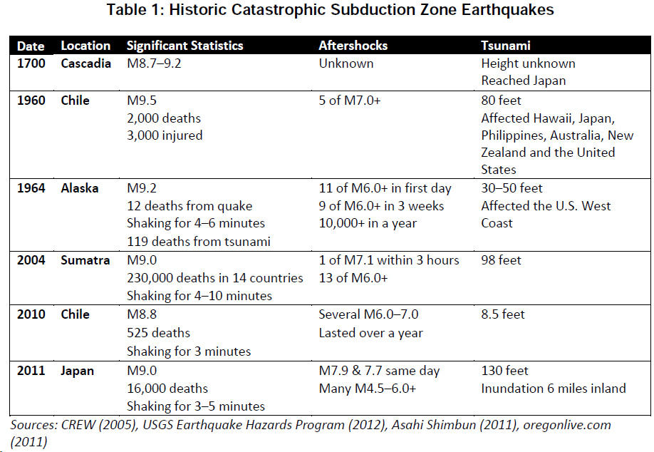
Check out this quote regarding the 1960 subduction zone earthquake in Chile, shown in the table above, which measured a whopping magnitude 9.58.
What became known as the Great Chilean Earthquake revealed something new about the planet — that the world itself can vibrate like a guitar string. The seismic waves went through every part of the globe, even its core. And because they were so strong, scientific instruments from around the world picked up the signal. When it was over, seismologists realized the earthquake had given them a window into Earth’s structure. Nature had given the planet something like an ultrasound scan.
How Might the CSZ Compare?
Thankfully not every megathrust earthquake ruptures along the entire 621.37 miles. Roughly half of them are partial ruptures.
According to a 2012 presentation by Oregon State University professor Chris Goldfinger, the largest CSZ earthquakes over the past 10,000 years were events T11 and T16. The latter created a turbidite about three times the mass of the most recent ~M9.0 earthquake on January 26th, 1700.9 What does that look like for estimating the PNW’s upper range of what magnitude is possible?
Oregon’s Department of Geology and Mineral Industries (DOGAMI) included a magnitude 9.4 as the largest hypothetical CSZ earthquake in its research, Variable Rupture Scenarios for Tsunami Simulations Inferred From a 10,000-Year History of Cascadia Megathrust Earthquakes.10
The USGS paper, Simulated tsunami inundation for a range of Cascadia megathrust earthquake scenarios at Bandon, Oregon, USA, states the following:
“The extra-large (XL) size class reflects a single event (T11) in the Holocene record of Cascadia turbidites (Table 1). T11 is the second largest turbidite by mass and has the longest post-event time interval (∼1150 yr). We rounded the interval for the extra-large scenario to 1200 yr for the purpose of modeling a hypothetical maximum earthquake with peak slip (>40 m) similar to the Mw 9.5 1960 southern Chile earthquake (Barrientos and Ward, 1990; Moreno et al., 2009).”11
To help visualize how large subduction zone megathrust earthquakes are, check out these quick videos comparing magnitude classes.
More information is available on Surviving Cascadia’s Potential Impact Area page.
Earthquake Lights: Fun Fact
According to the USGS, “Phenomena such as sheet lightning, balls of light, streamers, and steady glows, reported in association with earthquakes are called earthquake lights (EQL).”12 The cause of EQLs is not well understood by the scientific community, but there are theories.
“Prior to earthquakes, huge volumes of rock — hundreds of thousands of cubic kilometers of rocks in the Earth’s crust — are being stressed and the stresses are causing shifting of the grain, the mineral grains relative (to) each other…It’s like switching on a battery, generating electrical charges that can flow out of the stressed rocks into and through unstressed rocks. The charges travel fast, at up to around 200 metres per second.” – Friedemann Freund, adjunct professor at San Jose University and a former researcher at NASA Ames Research Center.13
So What Can You Do To Be Ready?
“You can, you should, and if you’re brave enough to start, you will.”
― Stephen King
When (not if) the earthquake and tsunami happen, water, wastewater, food distribution, electricity, and natural gas will all be heavily impacted. Bridges, air transportation, rails, roadways, and seaports will be compromised. Some fire and police departments, hospitals, and schools will be heavily damaged. So will some homes. Most communication systems will be down. (See Surviving Cascadia’s Expected Impacts page for more details).
Daily life will look all but unrecognizable. Getting ready for that eventuality takes planning! You are smart & resourceful. But being resourceful requires having access to resources. Those resources are plentiful now. Toilet paper anyone? (Hint: The resources won’t be plentiful after a major event).
Learning about the earthquake and tsunami that will hit the Pacific Northwest is flat-out scary. Striking without warning, earthquakes are some of the greatest ghost stories ever told. They are nowhere, then suddenly everywhere around us at once, unseen but for the destruction they cause.
Be Ready.
Be ready so that you don’t become a victim in need of saving. There are people (and pets!) who can’t prepare in advance the way you can. Be ready so you can help others when the time comes.
Just be ready.
Because you see, for most people, the true risk won’t be the earthquake itself. The true risk is not being ready for the earthquake’s aftermath.
As you travel along this journey seeking knowledge, as you take steps to prepare yourself and your loved ones, the fear will dissipate. It will transform into determination. Let this website serve as a guide on this journey. You’re here. That, in and of itself, is courageous. You’re taking the first step. Not all those around you will be so brave. Keep learning. Start planning. Prepare. Your loved ones will need you to be ready when the time comes.
There is a ghost on our horizon.
References
- Pacific Northwest Seismic Network. (n.d.). Cascadia Subduction Zone. https://www.pnsn.org/outreach/earthquakesources/csz
- United States Geological Survey. (2022, August 1). Cascadia Subduction Zone Marine Geohazards. https://www.usgs.gov/centers/pcmsc/science/cascadia-subduction-zone-marine-geohazards
- Oregon Military Department, Oregon Department of Emergency Management. (2012). Cascadia Subduction Zone Catastrophic Earthquake and Tsunami Operations Plan. State of Oregon. https://digital.osl.state.or.us/islandora/object/osl:68546
- Rizzo, A. (2014). The Impacts of the Cascadia Subduction Zone Earthquake on Oregon. Western Lane Emergency Operations Group. http://wleog.org/wp-content/uploads/2014/06/2015-hour-and-a-half-Cascadia-Infrastructure.pdf
- Richardson, D., & Memmott, K. (2018). The State Must Do More to Prepare Oregon for a Catastrophic Disaster [Report]. State of Oregon. https://sos.oregon.gov/audits/documents/2018-03.pdf
- Ezelle, R., Niles, P. P., Figuerres, P., & Sabarese Jr., R. A. (2022). Washington State 2022 Cascadia Rising Exercise Series Summary of Conclusions: Critical Transportation and Mass Care Services Tabletop Exercises [Report]. Washington State Emergency Management Division. https://mil.wa.gov/asset/6390e374e0f21
- United States Geological Survey. (n.d.). Why are we having so many earthquakes? Retrieved from https://www.usgs.gov/faqs/why-are-we-having-so-many-earthquakes-has-naturally-occurring-earthquake-activity-been
- Bichell, R. E. (2016, August 29). When The Biggest Earthquake Ever Recorded Hit Chile, It Rocked The World. NPR. https://www.npr.org/2016/08/29/490239181/when-the-biggest-earthquake-ever-recorded-hit-chile-it-rocked-the-world
- Goldfinger, C. (2012). Cascadia Great Earthquakes from Paleoseismic Data: A Progress Report on Marine, Lacustrine, and Onshore Evidence Moving toward Paleo-Slip Models [Presentation]. National Tsunami Hazard Mitigation Program. https://nws.weather.gov/nthmp/2012tsuhazworkshop/presentations/Goldfinger_presentation.pdf
- Witter, R., Goldfinger, C., Wang, K., Priest, G., & Zhang, Y. (2010). Variable Rupture Scenarios for Tsunami Simulations Inferred From a 10,000-Year History of Cascadia Megathrust Earthquakes. Oregon Department of Geology and Mineral Industries. https://www.oregon.gov/dogami/tsuclearinghouse/resources/Witter_2010_Chapman_poster-small.pdf
- Witter, R. C., Zhang, Y. J., Wang, K., Priest, G. R., Goldfinger, C., Stimely, L., English, J. T., & Ferro, P. A. (2013). Simulated tsunami inundation for a range of Cascadia megathrust earthquake scenarios at Bandon, Oregon, USA. Geosphere, 9(6), 1783–1797. https://pubs.geoscienceworld.org/gsa/geosphere/article/9/6/1783/132896/Simulated-tsunami-inundation-for-a-range-of
- United States Geological Survey. (n.d.). What are earthquake lights? Retrieved from https://www.usgs.gov/faqs/what-are-earthquake-lights
- Hunt, K. (2023, September 14). Strange lights spotted in Morocco earthquake videos may be a phenomenon reported for centuries, scientists say. CNN. https://www.cnn.com/2023/09/14/world/earthquake-lights-phenomenon-scn
Image Credits
Chock, G. (2022). ASCE 7-16 Chapter 6, Tsunami Loads and Effects [PowerPoint presentation]. Oregon Emergency Management. https://www.oregon.gov/oem/Documents/190910_A_ASCE%207-16%20Chapter%206,%20Tsunami%20Loads%20and%20Effects_Gary%20Chock.pptx.pdf
National Oceanic and Atmospheric Administration (2023, June 12). JetStream Max: Plate Tectonics and Earthquakes. NOAA.Gov. Retrieved January 18, 2024, from https://www.noaa.gov/jetstream/tsunamis/tsunami-generation-earthquakes/jetstream-max-plate-tectonics-and-earthquakes
Hunt, K. (2023, September 14). Strange lights spotted in Morocco earthquake videos may be a phenomenon reported for centuries, scientists say. CNN. https://www.cnn.com/2023/09/14/world/earthquake-lights-phenomenon-scn
Video Credits
Seismological Facility for the Advancement of Geoscience & Incorporated Research Institutions for Seismology (IRIS). (n.d.). GPS Measures Deformation in Subduction Zones: Ocean/continent: How Does Land Jump in an Earthquake? [Video]. IRIS Earthquake Science. https://www.iris.edu/hq/inclass/animation/gps_measures_deformation_in_subduction_zones_oceancontinent
Washington State Emergency Management Division. (2022). Disaster Planning: Cascadia Rising 2022 [Video]. FEMA PrepToolkit. https://preptoolkit.fema.gov/web/nle-2022/cascadia-rising-resources
Space.com. (2013). Earthquake: What Does ‘Magnitude’ Mean? [Video]. YouTube. https://www.youtube.com/watch?v=yNN7eDXzlMo&t=1s
Oregon Museum of Science and Industry (OMSI) & Oregon Public Broadcasting (OPB). (2015). How Big Is A 9.0 Earthquake? [Video]. YouTube. https://www.youtube.com/watch?v=c5VgIVNlJXE
